We had always wanted to try a whole new trail route. A route that neither we nor any of our friends would have ever followed through before and which we would some kind of create it ……while underway.
About two months ago, we had decided to stay in Athens for the weekend and for some reason no plans were made with our usual activities.
Despite being in the heart of autumn, we had woken up in a bright and rather warm sunny day. A feeling more similar to the one that someone gets when he wakes up during an early spring morning, was spread out all over our flat. The contrast between the luminous blue sky and our concrete-made ceiling made us yearning for the outdoors. It was the perfect occasion for us to try out having our long time wished sort-of-mapping mountain walk….
We agreed that the mountain of Parnitha was the most appropriate one in letting us carrying out the kind of hike we had in mind. Its trails are quite enough and some of them are crisscrossing. That was something very important for the scenario we had in mind, since it would provide us with a great deal of flexibility while determining both our direction and the duration of our hike. Apart from that, Parnitha is right next to the outskirts of Athens and in this way we wouldn’t have to spend most of our time driving on the way towards and back from our hiking site.
So, we took a look on our digital map, checked out our options and headed for the mountain.
 Having reached the start of the trail we would follow for a start, we decided to park on the side of the road and set off our hike.
The trail we chose to start our hiking was rather popular and pretty easy trail and was leading all the way up to the Bafi Refuge. That day, like all sunny days, the trail was rather crowded by casual visitors.
First time we saw crowded trails around that region, we thought that this was a really nice thing to happen. We believed that people searching for a way out of their every day routine, had at last decided to try and come closer to nature. But later on, we got really frustrated seeing that the actual purpose of their visit was simpy the subsequent revelling consumption of sausages, steaks, spaghetti and chocolate cakes, which they were usually having at the refuge’s restaurant right after they had completed their wandering-all-over-and-around sessions. What we had taken to be an “approach to nature”, was more like a prescribed redemption routine or a guilt-proof precautionary ritual for them, which they followed in advance so that they can participate unconditionally in these massive feasts.
We kept on heading our ways and soon enough, by-passed the parking lot of Bafi’s refuge and got out to the main road. We walked for a few meters uphill and then turned hard left into another trail.
 That trail was a bit steeper than the previous one and was labelled to lead all the way up to the region of Mola. Mola used to be a really nice place, but that was before the great fire of June 2007. So, we would definitely need to find another trail to follow before we would find ourselves hiking into the depressing burnt-trees zone.
We hiked all the way up that mountain slope and crossed the main road. The trail started heading downhill the moment we got off the tarmac. We were on the mountain ridge, close to the peak.

Earlier that day, we had started our route from the south side of the mountain, which is the side of the mountain actually facing the city of Athens, and now we were hiking along the east side, really close to Parnitha’s peak. Mola was somewhere north/ northeast, further on from the position we were standing.


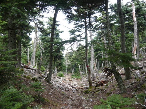
 We carried on our route. The atmosphere was less sunny and less warm. The air at this side of the mountain was much more moist and the trees were growing thicker and much taller. At last, it was silence! It felt and scented like being in the woods of some remote place. For a moment we thought we were far away from the city-madness, but in fact we were just half an hour drive from the busy city centre.
We walked for a while, till we got to a labelled junction informing us that the trail on the right was heading towards Mola. We took the left turn.
We were now hiking on the north side of the mountain and we were moving along the contour lines. The terrain was muddy and a bit slippery too, but it was almost level, so it didn’t cause us any hardship.
We were on the trail that was connecting Mola with the spring of Skipiza. The scenery seemed different and more wild and that was partly because of the climate conditions that usually prevail on the northern side of the mountain.
Parnitha, especially before the great fire on June 2007, has always been the meteorological filter of Athens. Both its morphology and its huge flora have played the role of temperature and metereological phenomena stabilizers. Parnitha’s huge mass has always been normalizing extreme weather conditions, both during winter and during summer, helping to avoid sharp changes in weather and extremely low or high temperatures..
As it’s easy for someone to imagine, such a contribution was not offered without any expense from the side of the mountain. The signs of heavy weather’s wrath were spread all over the northern side of the mountain.
We pushed on further west, till the north transverse trail was approaching to its final destination. A while before we reach Skipiza’s Spring, we took a left turn once more and started heading back to Bafi refuge.
The final leg of our hike was a completely different story. We started a slow descent among firs, pine trees, arbutuses and lentisks. The ground was curved by rainwaters and the trail in some steep parts had turned into a gully.
We crossed once more the main road and after hiking for a while on a treeless ridge, we came upon the exact thing we had been trying to avoid ever since we had started our hike. We had to enter and cross the “land of the dead”….!
It was a really sad scenery! Especially the fact of having seen and lived the place before its destruction by the great fire of June 2007, was making the whole thing even more depressing. The only plant that was still growing there were thistles. Really tall thistles. The absence of trees and bushes in combination with rain and unhindered sunbeams had created the perfect environment for them to thrive and grow up to one meter in height.
The trail was almost destroyed and any effort to follow it further was purposeless. We decided to abandon it and to escape off trail and down to the main road.
After following an improvised steep downhill route, we got ourselves down to the main road and about one kilometer off the place where we had started our hike earlier that day. We walked that last part of our hike silent and with our eyes nailed on the tarmac. Soonest we got to the car, we hopped in and drove off. We were trying to discard all the bad memories from the wasted beauty scenes we had witnessed.
We talked about our route and looked at the pictures “M” had shot along the way…. I was surprised and overwhelmingly glad to see that “M”, within this total destruction of burnt trees and tall thistles, had managed to capture in her camera the icon of hope….
Time had flown really fast and it was already late noon. 
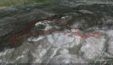
We were both starving and had started feeling this sweet tireness that usually takes over after completing a goal. We had completed a really nice improvised round route of about 10 kilometers around the mountain top of Parnitha and that was a small venture to remember for that day. It was a rather easy route and we will definitely try it again in future, but this time will have to make some small amendments so that we skip that burnt-down part.
At the end of the day, we felt lucky enough that while living in the city we are offered with the option to try out such brief getaways in a beautiful and easily accessible mountain like the mountain of Parnitha.
We really can’t wait for our next decide-along-the-way hike….
“N”


It sure is nice to have such places close from the city! The 3D map with the route is very useful to picture the hike. The name land of the dead seems really appropriate to the burned area ahah. Looks like a post apocalyptic place. Good report.
Thanks Orel. I thought that since this was a “mapping” hike, having a google-view map produced and adding it up along with the photos was the least we could do to prove ourselves consistent to the initial purporse of that hike ;-).
I dugg some of you post as I cogitated they were very helpful very beneficial
I just want to mention I am all new to weblog and certainly savored you’re website. Most likely I’m want to bookmark your blog . You absolutely come with wonderful stories. Regards for revealing your website.